Watersheds
What is a watershed?
A watershed is the entire land surface that drains into a particular river or stream. A watershed may also be called a catchment or drainage basin. A watershed for a large river is made up of the smaller watersheds for each creek or stream that flows into the river.
The Chesapeake Bay
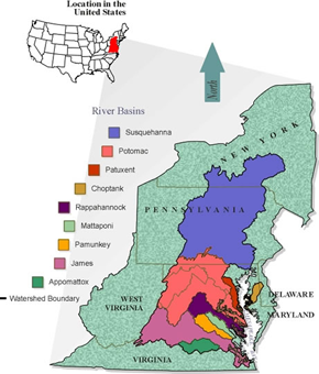
Charlottesville lies within the boundaries of the Rivanna River watershed. The Rivanna River watershed is part of the James River watershed, which is shown in pink on the Chesapeake Bay watershed map. The James River empties directly into the Chesapeake Bay. As a result, Charlottesville is a part of the Chesapeake Bay watershed. This means that all of the rainfall in the Charlottesville area could potentially reach the Bay.
UVA watersheds
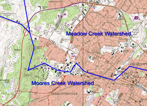
The two watersheds of the main grounds of the University are the Meadow Creek and the Moores Creek watersheds. Meadow Creek and Moores Creek are part of the Rivanna River watershed. The headwaters of Meadow Creek lie on the eastern flank of Observatory Hill and on the western side of the Grounds. At the base of Observatory Hill, Meadow Creek enters a stormwater sewer system that conveys the stream under the Facilities Management complex to just east of Alderman Road. The Moores creek watershed drains a large portion of University central grounds including most of the Lawn, Hospital Complex, Scott Stadium, Engineering school and residence halls from Alderman Road to Hereford. The stream itself is not found anywhere on grounds, but smaller streams, such as Rock Creek, Lodge Creek, and Morey Creek are tributaries that drain into Moores Creek.